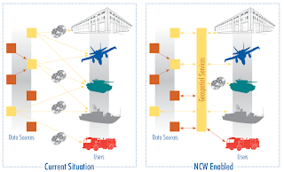
The Australian Defence Geospatial Strategy 2010 outlines how Defence intends to embrace the use of standards within a Service Oriented Architecture (SOA) for delivering geospatial functionality.
The application of Defence geospatial information and technology standards is vital to achieving a geospatially networked force. In order to allow geospatial information to be delivered seamlessly across the network from the strategic to the tactical level the capabilities that Defence acquires in the future must be able to ingest standard data formats. Non-compliance with standards will result in additional costs and delays in the acquisition of systems. Once operational, non-compliant platforms adversely affect interoperability and create an ongoing requirement to convert proprietary data formats into standard data formats resulting in systems that are expensive and unsupportable in the long term. It is important, therefore, that Geospatial Standards, including metadata standards, are collaboratively developed, managed and published across all of Defence.This move toward standards will be particularly valuable for Australia's long term spatial capabilities as defence initiatives will also benefit geospatial services in government and private sectors.
[Image sourced from the Defence Geospatial Strategy 2010]
No comments:
Post a Comment